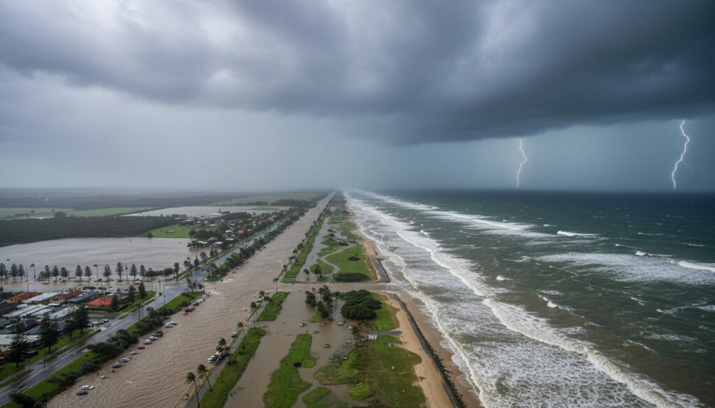
Cyclone Alfred Sunshine Coast – Record Rainfall and Floods
Severe Tropical Cyclone Alfred delivered record-breaking rainfall and damaging winds to southeast Queensland in March 2025, transitioning from a powerful category 4 offshore system to a subtropical cyclone that made landfall near Bribie Island on 8 March. The event triggered the first tropical cyclone watch for Brisbane since 2019 and generated widespread flooding across the Sunshine Coast, with Upper Springbrook recording 1146 millimetres over seven days.
By 10 March, the Bureau of Meteorology classified Alfred as an ex-tropical cyclone as authorities shifted from emergency preparedness to recovery operations. The system’s erratic westward loop through the Coral Sea and its final approach toward densely populated coastal areas marked it as one of the most significant meteorological events to affect the region in recent years.
Records indicate the cyclone caused severe coastal erosion, power outages, and structural damage across both southeast Queensland and northeastern New South Wales.
What is the current status of Cyclone Alfred?
Ex-tropical cyclone; recovery phase active as of 10 March 2025
Bribie Island and mainland Queensland near Sunshine Coast vicinity
Category 4 (90 knots / 165 km/h 10-minute winds) on 28 February
1146 mm at Upper Springbrook (7-day total to 9am 10 March)
- Alfred formed as Tropical Low 22U on 21-23 February and was named on 23 February approximately 320 km northeast of Willis Island
- The system peaked at category 4 intensity on 28 February while remaining offshore in the Coral Sea
- It underwent multiple transitions between tropical and subtropical status before final landfall
- The Bureau of Meteorology issued the first tropical cyclone watch for Brisbane since Cyclone Oma in 2019
- Nambour on the Sunshine Coast recorded 365 mm in 24 hours, establishing a new annual daily record
- Coastal erosion reached 1-in-20 to 1-in-50 year event levels with waves peaking near 7 metres
- By 10 March 2025, Queensland authorities had transitioned to recovery phase operations
| Fact | Details |
|---|---|
| Formation Date | 21-23 February 2025 |
| Naming Date | 23 February 2025, 10am AEST |
| Peak Category | 4 (90 knots / 165 km/h 10-minute winds) |
| Peak Duration | 4am to 10pm AEST, 28 February 2025 |
| Landfall (Island) | 8 March 2025, 8pm AEST at Bribie Island |
| Landfall (Mainland) | 8 March 2025, 9pm AEST as ex-tropical cyclone |
| Maximum 7-day Rainfall | 1146 mm at Upper Springbrook (to 9am 10 March) |
| Maximum Wave Height | Approximately 7 metres |
| Primary Affected Areas | Southeast Queensland, Sunshine Coast, Northern NSW |
| Official Sources | Bureau of Meteorology, Wikipedia records |
How has Cyclone Alfred impacted the Sunshine Coast?
Rainfall and Flooding Records
Nambour recorded 365 millimetres in the 24 hours to 9am on 10 March, establishing a new annual daily rainfall record for the location. Hervey Bay experienced 189 millimetres in just two hours on 9 March. Over the full seven-day period ending 10 March, Gold Coast hinterland areas, Northern Rivers in New South Wales, and the Clarence River catchment all received totals exceeding 800 millimetres.
The Sunshine Coast bore the brunt of sustained precipitation, with Upper Springbrook registering 1146 millimetres and Lower Springbrook recording 1048 millimetres over the same seven-day window. These totals caused severe flooding across the region, inundating infrastructure and cutting road access in multiple locations.
Upper Springbrook recorded 1146 millimetres over seven days, while Lower Springbrook received 1048 millimetres during the same period, representing exceptional totals for the region.
Coastal Erosion and Wind Damage
Damaging wind gusts reached up to 220 km/h offshore, causing widespread power outages and structural damage across southeast Queensland and northeastern New South Wales. University of the Sunshine Coast research documented severe erosion of beaches and dunes, with wave heights peaking at approximately seven metres.
The coastal impact represented a 1-in-20 to 1-in-50 year event, exacerbated by prior erosion along the coastline. High tides combined with large swells created overtopping risks and flooding in low-lying coastal areas, though the system weakened to a tropical low shortly before landfall, reducing the wind impact from initial fears.
What are the warnings and evacuations for Cyclone Alfred on the Sunshine Coast?
Tropical Cyclone Watch Coverage
On 3 March, the Bureau of Meteorology issued a tropical cyclone watch extending from Sandy Cape in Queensland to Grafton in New South Wales, covering the Sunshine Coast, Brisbane, Gold Coast, and Byron Bay. This marked the first such watch for Brisbane since Cyclone Oma in 2019, signalling the rare threat to densely populated southeastern areas.
The Bureau of Meteorology issued a Coastal Hazards Warning on 28 February for damaging surf and high tides affecting the Sunshine Coast to Coolangatta, with waves peaking at approximately seven metres.
Emergency Preparations and Response
Queensland Government emergency reports confirm that preparations included evacuations across southeast Queensland and northern New South Wales, targeting populated areas rarely exposed to direct cyclone impacts. The event was deemed one of Australia’s most significant recent weather events, prompting the shift to recovery phase immediately following the 8 March landfall.
Preparations included evacuations across southeast Queensland and northern New South Wales, targeting populated areas rarely exposed to direct cyclone impacts.
What is the timeline and path of Cyclone Alfred?
Formation and Offshore Intensification
Alfred originated in the Coral Sea northeast of Queensland, initially moving east before turning southward. The system intensified to category 4 status far offshore, remaining over open waters during its peak intensity phase. Bureau meteorological briefings tracked the cyclone’s generation of large swells approaching the southeast Queensland and northern New South Wales coasts during this period.
Westward Approach and Subtropical Transition
After weakening to category 1 over Cato Island on 2 March, the system steered southeast and re-intensified to category 2 before undergoing subtropical transition by 4pm AEST on 3 March. Erratic westward motion brought the cyclone toward the Queensland coast, where it reclassified as tropical category 1 on 5 March and intensified to category 2 by 6 March before becoming subtropical again prior to landfall. For those interested in the latest tech releases, you can read AirPods Pro 3発売日.
When did Cyclone Alfred form and make landfall in Queensland?
- 21-23 February 2025: Tropical low 22U formed northeast of Cooktown, moved east, and was named Alfred at 10am AEST on 23 February, positioned 320 km northeast of Willis Island.
- 24-28 February: Turned south, intensified to category 4 peak (90 knots/165 km/h 10-minute winds) from 4am to 10pm AEST on 28 February, remaining offshore.
- 1-2 March: Weakened to category 1 by 10am AEST 2 March over Cato Island, east of Rockhampton.
- 2-3 March: Steered southeast, re-intensified to category 2, underwent subtropical transition by 4pm AEST 3 March (45-55 knots).
- 4-5 March: Turned west toward southeast Queensland coast with slow, erratic motion; reclassified as tropical category 1 at 10pm AEST 5 March.
- 6 March: Intensified to category 2 at 4am AEST.
- 7-8 March: Became subtropical again; crossed Bribie Island at 8pm AEST and mainland at 9pm AEST 8 March as ex-tropical cyclone.
- 9-10 March: Heavy rain continued; highest 7-day totals to 9am 10 March reached 1146 mm at Upper Springbrook and 1048 mm at Lower Springbrook.
Additional video updates were provided via emergency service channels throughout the event.
What is confirmed about Cyclone Alfred and what remains unclear?
| Established Information | Information That Remains Unclear |
|---|---|
| Landfall occurred at Bribie Island at 8pm AEST on 8 March and mainland at 9pm AEST as an ex-tropical cyclone | Specific monetary costs of infrastructure damage remain unquantified in available records |
| Peak intensity reached category 4 (90 knots/165 km/h) offshore on 28 February 2025 | Long-term ecological impacts on coastal dune systems require ongoing assessment |
| Maximum verified rainfall of 1146 mm recorded at Upper Springbrook over seven days | Complete structural damage assessments for all private properties are pending |
| First tropical cyclone watch for Brisbane since Cyclone Oma in 2019 | Exact localised wind gust measurements at every individual Sunshine Coast monitoring station |
How does Cyclone Alfred fit into Queensland’s cyclone history?
The event marked the first tropical cyclone watch issued for the Brisbane area since Cyclone Oma in 2019, highlighting the rarity of such threats to southeast Queensland’s densely populated coastal corridor. While tropical systems frequently impact northern Queensland, cyclones maintaining sufficient intensity to threaten Brisbane and the Sunshine Coast remain uncommon meteorological events.
The system’s transition from intense tropical cyclone to subtropical status before landfall represents a complex meteorological pattern that has become increasingly relevant to regional preparedness planning. While political figures such as Pauline Hanson Net Worth continue to feature in state discourse, the cyclone dominated regional emergency management priorities throughout early March.
What do official sources report about Cyclone Alfred?
By 10 March 2025, Alfred was an ex-tropical cyclone with lingering heavy rain/flooding; preparedness ended, transitioning to recovery operations.
— Queensland Government Emergency Services
Severe Tropical Cyclone Alfred (22U) was a long-lived system that formed in February 2025, peaked at category 4 intensity offshore, made landfall as a subtropical cyclone near Bribie Island on 8 March 2025.
— Bureau of Meteorology Cyclone History Records
What are the key outcomes of Cyclone Alfred for the Sunshine Coast?
Cyclone Alfred concluded its lifecycle as an ex-tropical system by 10 March 2025, having delivered record-breaking rainfall to the Sunshine Coast and generated significant coastal erosion despite weakening before landfall. The event established new daily precipitation records at Nambour and triggered the first Brisbane cyclone watch since 2019, demonstrating the ongoing vulnerability of southeast Queensland to tropical systems. Recovery operations continue while communities assess the long-term impacts of the 1146 millimetre rainfall totals and seven-metre waves that affected the region. Sporting events like the Broncos vs Panthers 2025 matchup proceeded alongside these recovery efforts, illustrating the region’s resilience.
Frequently asked questions about Cyclone Alfred
What was the highest wind speed recorded during Cyclone Alfred?
Offshore gusts reached approximately 220 km/h during the cyclone’s peak intensity on 28 February, though speeds were significantly lower at landfall.
Which Sunshine Coast location received the most rainfall?
Upper Springbrook recorded 1146 millimetres over seven days ending 9am on 10 March 2025, the highest verified total for the event.
What time did Cyclone Alfred make landfall at Bribie Island?
The system crossed Bribie Island at 8pm AEST on 8 March 2025, reaching the mainland at 9pm AEST the same evening.
Was this the first cyclone to threaten Brisbane in recent years?
It was the first tropical cyclone watch issued for Brisbane since Cyclone Oma in 2019, marking a significant meteorological event for the region.
What is the difference between a tropical and subtropical cyclone?
A subtropical cyclone derives energy from both warm ocean waters and atmospheric temperature contrasts, unlike purely tropical systems which rely solely on ocean heat.
How long did the heavy rainfall continue after landfall?
Heavy rainfall persisted through 9-10 March, with major totals recorded up to 9am on 10 March before conditions began to ease.
What areas were covered by the tropical cyclone watch?
The watch covered areas from Sandy Cape in Queensland to Grafton in New South Wales, including the Sunshine Coast, Brisbane, Gold Coast, and Byron Bay.
More related posts
 Flights to Melbourne from Adelaide: Fares, Airlines & Flight Time
 Black Cat Meaning: Superstitions, Catholic Church, and Facts
 Human Cat Years: How to Calculate Your Cat’s Age in Human Years
 Ben Ainsworth: Why He Left Gold Coast, Position, Stats & Career
 Eugene Levy: Ethnicity, Religion, and Career Facts
 Zan Rowe Biography: Age, Partner, Career, and More
 Ashley Judd: Health, Partner, Children, and Weinstein Lawsuit
 Band Aid: The Charity Supergroup vs. The Bandage Brand
